Louisiana is facing an unprecedented dual threat of a Category 1 Hurricane Marco, with top winds of 75 mph hitting the state's coastline by 7 p.m. Monday, and a Category 2 Hurricane Laura, with top winds of 100 mph, smashing ashore at the Louisiana-Texas border early Thursday, according to forecasters with the National Hurricane Center.
Forecasters warned that the landfall locations for both storms remain subject to change, and that those living anywhere along the Louisiana coast should be preparing for hurricane conditions.

Officials with the Slidell office of the National Weather Service warned Sunday that the stronger Laura could bring more significant impacts across south Louisiana, because of its potential for higher winds and storm surge, and because preparing for Laura will likely be complicated by lingering impacts from Marco.
RELATED: NOLA Public Schools is canceling class Monday and Tuesday.
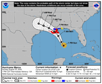
At 1 p.m. Sunday, Marco remained at hurricane strength about 280 miles south southeast of the mouth of the Mississippi River, and 440 miles southeast of Lafayette, moving north northwest at 14 mph. An Air Force Reserve Hurricane Hunter aircraft found that Marco had maximum winds of 75 mph.
Marco is expected to make landfall near Grand Isle just before 7 p.m. Monday, and then slowly push west northwest through the central part of the state, brushing just west of Baton Rouge as a 40 mph tropical storm by 7 a.m. Tuesday, and reaching the Texas border as a depression by 7 p.m. Tuesday.

Marco has about 12 to 24 hours to intensify as it passes over an area in the Gulf of Mexico with only moderate southwesterly wind shear, very warm waters and plenty of atmospheric moisture, said NHC Hurricane Specialist Andrew Latto in a 10 a.m. forecast discussion message.
"After that time, the vertical wind shear is expected to increase and this should begin to dominate the cyclone's environment," Latto said. And while the storm could weaken just prior to landfall, it won't make much difference in terms of its windspeed impacts, he said.

A hurricane warning has been issued for coastal southeastern Louisiana ahead of impacts from Tropical Storm Marco, National Hurricane Center f…
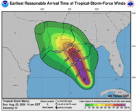
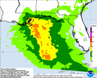
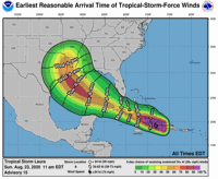
The earliest arrival time for tropical storm force winds on the coast south of New Orleans for Marco is 2 a.m. Monday.
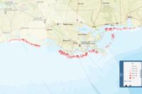
Mandatory evacuations have been ordered for large portions of Plaquemines Parish inside and outside its levees, for Grand Isle and other Jefferson Parish locations outside levees, and for Port Fourchon and locations in coastal parishes west of New Orleans outside levee systems.
Gov. John Bel Edwards on Saturday declared a state of emergency, a necessary step for the state in preparing in advance to obtain financial and other assistance from the Federal Emergency Management Agency and other federal agencies once a storm hits.
In New Orleans, the Sewerage & Water Board says all but one pump station and all but one electric generator are available in the event of flash flood conditions. The city has lifted restrictions on parking on neutral grounds, beginning at 6 p.m. Sunday.
The major threats for the compact-sized Marco will be high winds along the coast, with gusts just above hurricane force. In New Orleans, winds of 65 mph are possible, with higher gusts.

Hurricane warnings are in effect from Morgan City to the mouth of the Pearl River. A tropical storm warning and hurricane watch are in effect for metro New Orleans and the north shore.
A tropical storm watch is in effect for the Baton Rouge area and Lafayette.
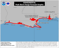
A storm surge warning also is in effect from Morgan City to the mouth of the Pearl River, with storm surge watches in place from Sabine Pass to Morgan City and in Lakes Pontchartrain and Maurepas. Water heights of 4 to 6 feet are possible from Grand Isle to the Pearl River, including Lake Borgne, with water heights of 2 to 4 feet elsewhere, including Lakes Pontchartrain and Maurepas.
Rainfall rates of 2 to 4 inches are expected across the region, with some locations possibly seeing 6 inches.

Hurricane Laura is expected to make landfall at the Texas-Louisiana border early Thursday morning, and follow a northerly curve that will likely take it over Shreveport Thursday night, possibly still with tropical storm force winds, before it decelerates into a tropical depression in northern Arkansas by 7 a.m. Friday.
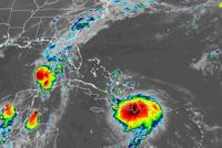
At 1 p.m., Tropical Storm Laura was 55 miles south of the eastern tip of Cuba and 80 miles southeast of Guantanamo Bay, with winds of 50 mph, moving west northwest at 21 mph.

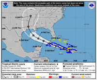
While still a tropical storm as it moved across the mountainous island of Hispanola and Cuba on Sunday, the storm continued to get better organized, forecasters said, and is expected to rapidly gain strength on entering the Gulf on Monday.

"By 48 hours and continuing until landfall, Laura is forecast to remain in a low shear and very favorable upper-level outflow environment wile passing (over) extremely warm sea surface temperatures near (88 degrees)," said Senior Hurricane Specialist Stacy Stewart in a 10 p.m. forecast discussion message. "This should allow for significant strengthening to occur once the cyclone regains a decent inner core after exiting Cuba."

This map shows where the U.S. Geological Survey expects beach erosion from Hurricane Marco because of "collision" of waves, overwash by surge and waves, and inundation by surge, identified as three color-coded layers along beach segments. The estimated erosion does not include wetland damage.
The U.S. Geological Survey is warning that the dual storm surge and wave threat of the two storms is likely to cause significant erosion to Louisiana beach areas.


The New Orleans Sewerage and Water Board said Saturday afternoon that 98 of its 99 drainage pumps, four turbines and five elctro-motive diesel…


As Tropical Storms Marco and Laura head for a potential landfall two days apart in southeast Louisiana next week, New Orleans officials will s…


The following schools have announced they are closing in advance of Hurricanes Marco and Laura.


A mandatory evacuation is in effect for Grand Isle beginning at 9 a.m. Sunday as tropical storms Marco and Laura approach Louisiana, Mayor Dav…


Tropical storms Laura and Marco will likely make landfall in Louisiana as hurricanes within the next few days, which means it's time to make s…
"news" - Google News
August 23, 2020 at 10:45PM
https://ift.tt/31jDh95
Marco, now a hurricane, to move onshore Monday in Louisiana; Laura's track shifts west - NOLA.com
"news" - Google News
https://ift.tt/2DACPId
https://ift.tt/2Wh3f9n
Bagikan Berita Ini


0 Response to "Marco, now a hurricane, to move onshore Monday in Louisiana; Laura's track shifts west - NOLA.com"
Post a Comment