- Tropical Depression Fred is moving between eastern Cuba and the southeastern Bahamas.
- Flooding rainfall and gusty winds could impact Hispaniola, the Bahamas and Cuba through late week.
- Fred could bring rain and wind impacts to Florida this weekend, but details are uncertain.
Tropical Depression Fred is back moving between eastern Cuba and the southeastern Bahamas and is expected to remain disorganized over the next day, but some strengthening is possible beginning later this week. Florida will see rain and wind impacts from Fred as early as late Friday, but details on the magnitude of those threats are still uncertain.
For now, Floridians should monitor the forecast closely given Fred's current most likely path.
Fred moved inland just west of Santo Domingo in the Dominican Republic about 2 p.m. EDT Wednesday and continues to bring heavy rain to parts of Hispaniola. It's tracking toward the west-northwest at 16 mph.

Current Satellite
(The icon shows the current location of this tropical system.)Tropical storm watches have been issued for the northern parts of Haiti, the southeastern Bahamas and portions of Cuba. Tropical storm conditions (winds of at least 39 mph) are possible on Thursday.
The Dominican Republic and the western Bahamas could see 3 to 5 inches (locally up to 8 inches) of rainfall from this system. Flash flooding and mudslides are concerns.
Haiti, the Turks and Caicos, eastern Bahamas and eastern Cuba, are expected to receive 1 to 3 inches of rainfall, with isolated totals of 5 inches. Across the western Bahamas, 3 to 5 inches of rainfall is possible with isolated totals up to 8 inches.
Uncertain Forecast For Florida
The official forecast from the NHC below shows that Fred will move generally west-northwest with a turn more to the northwest over the next few days.
The combination of moderate wind shear and land interaction with Cuba will likely prevent Fred from strengthening much, if at all, Thursday. There is even the possibility that the system could dissipate for a time.

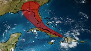
Current Status, Forecast Path
(The red-shaded area denotes the potential path of the center of the system. It's important to note that impacts (particularly heavy rain, high surf, coastal flooding, winds) with any tropical system usually spread beyond its forecast path.)Fred or its remnants could be located near Cuba and the southeast Bahamas Friday, where some slow reorganization of the system might begin. That will depend on several factors, including how much wind shear it encounters as it moves north, how quickly it recovers from land interaction and whether it tracks over water instead of Cuba.
Then, it could be near the western coast of the Florida Peninsula this weekend with little additional strengthening, as depicted by the far right side of the forecast path above. There is also the possibility that Fred could track into the eastern Gulf of Mexico, where wind shear might weaken enough to allow some intensification.
Keep in mind that Fred's forecast is highly subject to change given all of the wind shear and land interaction obstacles we've described above.
Regardless, it appears at least some rain and wind impacts are possible in Florida later Friday into this weekend. Details on the magnitude of those impacts are still uncertain, but will come into focus over the next day or so.
However, increasing moisture will likely impact parts of South Florida and the Keys, where 3 to 5 inches are possible Friday through Monday, with isolated maximum totals of 8 inches, according to the National Hurricane Center. The heavy rainfall could lead to flash flooding and rapid river rises.

Rainfall Forecast
(Locally heavier amounts are possible.)For now, interests from the Caribbean to the Bahamas and Florida should monitor its progress over the coming days. Now is a good time to refresh or develop your hurricane season plans.
The Weather Company’s primary journalistic mission is to report on breaking weather news, the environment and the importance of science to our lives. This story does not necessarily represent the position of our parent company, IBM.
"news" - Google News
August 12, 2021 at 04:19PM
https://ift.tt/3fYoKGO
Tropical Depression Fred Tracking Near Cuba, Southeastern Bahamas on a Potential Path Toward Florida | The Weather Channel - Articles from The Weather Channel | weather.com - The Weather Channel
"news" - Google News
https://ift.tt/2DACPId
https://ift.tt/2Wh3f9n
Bagikan Berita Ini


0 Response to "Tropical Depression Fred Tracking Near Cuba, Southeastern Bahamas on a Potential Path Toward Florida | The Weather Channel - Articles from The Weather Channel | weather.com - The Weather Channel"
Post a Comment